Precolonial North American History: The colony of Bartholomew Gosnold

A largely forgotten man named Bartholomew Gosnold made the first English attempt to colonize New England.

Gosnold was born in 1561 into an East Anglian manorial family. He got his first taste at sea in the Essex/Raleigh Expedition to the Azores in 1597, and upon his return, somehow got the colonization bug. It had been fifteen years since Walter Raleigh’s third attempt to settle at Roanoke had resulted in the famous “lost colony.” Gosnold ignored the fact that Sir Walter had the royal charter authorizing him to explore, colonize, and rule unoccupied North American territory.

Gosnold was initially backed by Robert Devereux, Earl of Essex, but his plan got stalled when the earl was beheaded in 1601 for conspiring against Queen Elizabeth. Gosnold regrouped and obtained the support of Henry Wriothesley, third earl of Southampton, although he too was imprisoned for a while as part of the Essex plot.

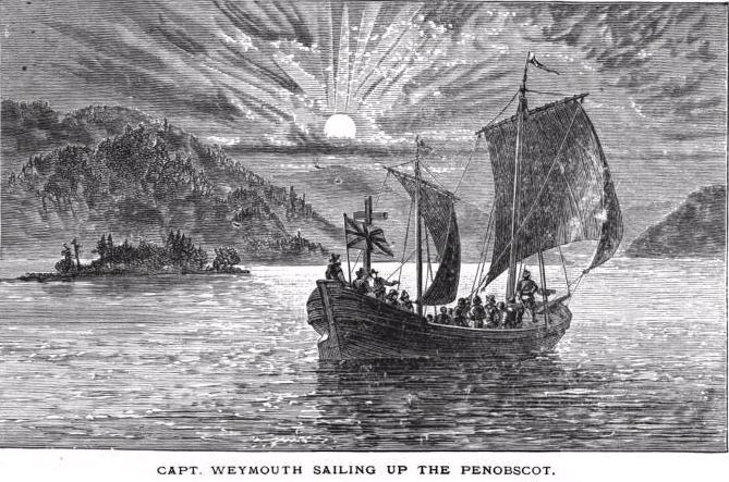
On March 26, 1602, Gosnold’s expedition departed Falmouth on the ship Concord, carrying twenty gentleman colonists and a dozen crewmembers. The Concord was a small, uncomfortable ship that had a keel length of only 39 feet, a breadth of 17½ feet, and leaked badly. Instead of making a circuitous route to North America by the Canary Islands as other explorers had done, Gosnold traveled due west and was the first to travel a direct route to New England. In only seven weeks, he made landfall at what is now Cape Elizabeth, near Portland, Maine. While exploring the area, he famously encountered a Mi’kmaq who was wearing black serge breeches and a European waistcoat. 

In May 1602,  Gosnold continued southward in search of an appropriate site for settlement. He navigated around a peninsula he named Cape Cod, after the large number of fish swimming in the surrounding waters. He went ashore there and was among the first Europeans to trade with the Nauset people. Continuing on, he discovered a large island he named Martha’s Vineyard in memory of his first child and the wild grapes that covered it.  

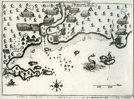
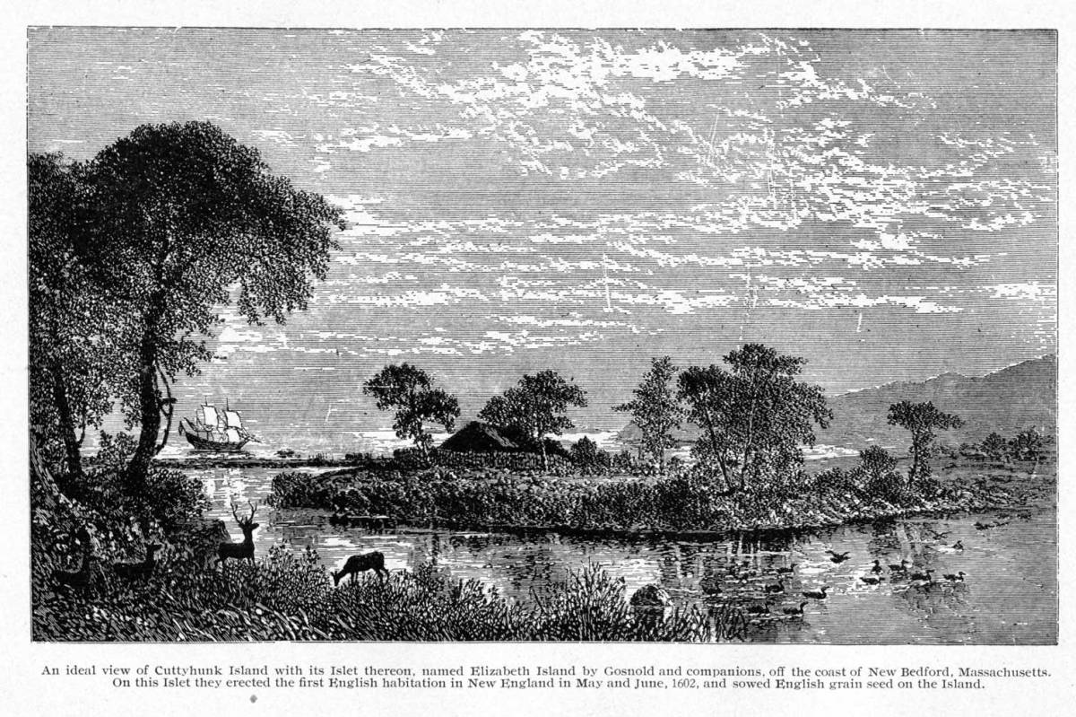
At Martha’s Vineyard, Gosnold encountered the Wampanoag people, who proved to be friendly, bringing the Englishman cooked fish, deerskins, and tobacco. Gosnold  kept on moving, and finally selected the small island of Cuttyhunk, west of Martha’s Vineyard, for his settlement. Here he built a small fort on an island in the middle of a large freshwater lake, which he reached with a flat-bottomed boat.   

The colonists found fertile land and plenty of sassafras to harvest, which would bring them a high profit in England. In the early 1600s, sassafras was believed to be a wonder drug that could cure just about anything. It became so popular that by the mid-1600s, it was America’s number two export to Europe, second only to Virginia tobacco.

As the summer progressed, Gosnold and the locals traded actively and had mostly congenial interactions. A group of six or seven of them even worked side-by-side with Gosnold’s men, helping cut and carry the sassafras.

As the summer progressed, the colonists began to lose their enthusiasm for settlement, realizing that their supplies were likely too short to last the winter. They also had an unfortunate skirmish where two Englishmen hunting for shellfish were attacked by four locals who shot one in the side with an arrow. This incident scared the colonists, making clear how vulnerable their little settlement was to the whims of the Indigenous people.

The original plan was for the colonists to split into two groups when their ship was full of sassafras – one group was to sail back to England with their harvested bounty and the other was to stay through the winter. After a sharp dispute as to who would go and who would stay, Gosnold gave in to a majority vote, and after only a month on the island, everyone sailed back to England, carrying a profitable cargo of cedar wood, sassafras, furs, and a stolen Wampanoag canoe.

Soon after their return, Sir Walter Raleigh found out about Gosnold’s mission and laid claim to the cargo.  However, the two quickly make peace. Gosnold had many powerful friends like the Earl of Southampton and Raleigh came to see the success of the mission as a good advertisement for future ventures that he might conduct.  

The colony of  Gosnold’s would be ephemeral, but its story would live long after. William Shakespeare based his play “The Tempest” on Gosnold’s 1602 voyage, with Prospero’s island being drawn from the descriptions of Martha’s Vineyard.

Gosnold would go on to be one of the key organizers of the successful Jamestown settlement.  Now mostly forgotten, he deserves much greater recognition. Dana Huntley (2023) calls Gosnold: “a man who perhaps more than any other single individual is responsible for the establishment of British North America, a man whom history ought to have recognized in one sense as at least the Founding Grandfather of these fair colonies.”
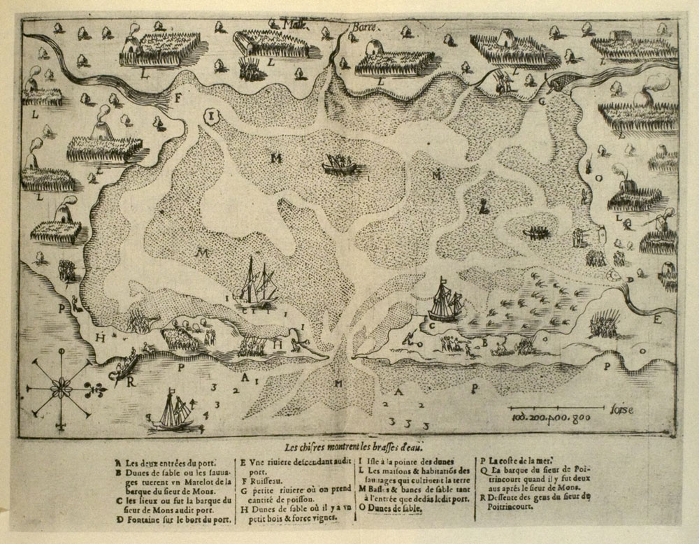
Illustration:

Artist’s conception of the fort built by Bartholomew Gosnold’s expedition on Elizabeth Islet, Cuttyhunk in May/June 1602. Robert Maitland Brereton, Reminiscences of an Old English Civil Engineer 1858-1908.

Bibliography:

Quinn, D. B. and Quinn, A. M. (1983) Gabriel Archer’s account of Captain Bartholomew Gosnold’s voyage to ‘North Virginia’ in 1602. In: The English New England voyages, 1602-1608. Hakluyt Society, London. pgs 112-138.

Huntley, D. (2023) Bartholomew Gosnold – How England settled in the New World. British Heritage Travel. https://britishheritage.com/history/bartholomew-gosnold-englands-settled-new-world

Levermore, C. H. (1912) Forerunners and Competitors of the Pilgrims and Puritans. 2 vols. Brooklyn: New England Society.

Precolonial North American History: Indigenous traders in the Gulf of Maine

When the English began exploring the coast of Maine in the early 17th century, they were astonished to find that the local people already had European manufactured goods. Incredibly, the first Englishman to land in Maine (at Cape Elizabeth) in 1602, Bartholomew Gosnold, was hailed from a Biscay shallop by a man wearing black serge breeches and a European waistcoat.

As Gosnold’s chronicler Gabriel Archer described:  “… there came towards us a Biscay shallop with sails and oars, having eight people in it, whom we supposed at first to be Christians distressed, but approaching us near, we perceived them to be savages. These coming within call hailed us and we answered. Then, after signs of peace and a long speech by one of them, they came boldly aboard us, all naked, having about their shoulder’s certain loose deerskins, and near their waists sealskins tied fast to Irish trousers. One that seemed to be their commander wore a waistcoat of black, a pair of breeches, cloth stockings, shoes, a hat, and a band … they spoke diverse Christian words and seemed to understand much more than we …”  (Quinn and Quinn, 1967a:117).

So, while Europeans themselves had had no contact with the coast of Maine before 1602, their manufactured goods had already found their way into the region. The only source of these materials could have been Basque–Eastern Eichmann contacts along the far-off coasts of Newfoundland, Labrador, and the Gulf of St. Lawrence. Incredibly, soon after the first Europeans touched  Atlantic Canada, an extensive indigenous trade route evolved across Eastern Canada and New England for coveted manufactured goods.  

Rapidly following Cabot’s discovery of the cod fisheries of the Great Banks of Newfoundland in 1497,  Breton, Norman, and Basque fishing crews began exploiting the rich fishing beds along the coast of eastern Canada, setting up numerous temporary fishing camps to salt and dry the cod. By the 1540s, merchants in the Spanish and French Basque provinces had also begun to mount whaling voyages to this region and established numerous stations to extract whale oil.

Fur trading emerged in the second half of the 16th century as a means for fisherman and whalers to diversify their income. When the fishermen and whalers began visiting the coast, they came in increasing contact with the local Indigenous people. The fisherman began trading primarily metal objects for robes made of native-tanned beaver pelts, called castor gras by the French. Initially, the robes were used by the fisherman for warmth on the cold Atlantic crossings, but in the second half of the 16th century, it was discovered that these pelts could be converted into felt to make hats. A new industry was subsequently born when beaver-felt hats became the rage in Europe. 

Fishermen from the Province of Normandy, in northwestern France, were the first to take up trading in North America.  Notarial records show the first outfitting for the fur trade began about  1550.  These traders were bound for what was referred to as “Florida”, which then constituted all of eastern North America from Florida to Cape Breton Island.

Basque whalers soon followed the Norman fishermen into fur trading, with 15 ships being outfitted annually in the 1580s. They combined whaling with trading near the mouth of the Saguenay River (Turgeon, 1998). Brittany fishermen joined the Basques as fur traders in the late 16th century.

Bourque and Whitehead (1985) propose two routes for European goods to get to the Gulf of Maine. In the first, Etchemin carried furs and hides up the St. John and Penobscot Rivers and down the Riviere du Loup and Chaudiere in return for trade goods from those areas. The second route was taken by shallop-sailing Amerindians ranging the entire Gulf Coast bartering European goods brought from the St. Lawrence. By the time this pattern of trade was first observed in 1602 by Gosnold, it may have been in place for decades and probably ranged as far west as Massachusetts Bay. Thus, a massive exchange network was extending from Newfoundland to Cape Cod and stretching inland from the Gulf of Maine to far beyond the St. Lawrence Valley.

The people moving the goods across Nova Scotia to the Gulf of Maine and Cape Cod by boat were called by the English “Terrantines”. The exact nature of this term is disputed but these Indigenous traders probably represented what Champlain called the Souriquois (Mi’kmaq) of Nova Scotia and their neighboring Etchemin (Passamaquoddy and Maliseet) across the Bay of Fundy. Secoudon and Messamouet, who would later travel with Champlain in 1606 from St. Croix Island to Saco, Maine were Terrantines.  

Illustration: Basque settlement sites dating from the 16th and 17th centuries.Based on a map by Gérard Galliene (Quebec), illustrating the ”Les Basques dans l’estuarie du Saint-Laurent” by René Belanger. 1971. 

Bibliography

Bourque, B. J. and Whitehead, R. H. (1985) Tarrentines and the introduction of European trade goods in the Gulf of Maine. Ethnohistory 32(4): 327 – 341.

Prins, H. E. L. and McBride, B. (2007) Asticou’s Island Domain: Wabanaki Peoples at Mount Desert Island 1500-2000. Acadia National Park. Ethnography Program. National Park Service, Boston, MA. 

Turgeon, L. (1998). French fishers, fur traders, and Amerindians during the sixteenth century: History and Archaeology. The William and Mary Quarterly 55(4), 585-610.

Quinn, D. B. and Quinn, A. M.  (1983) The English New England voyages 1602 – 1608. Volume 161 of the Hakluyt Society, London

Precolonial North American History: The French colony at Port Royal

To avoid another bitter cold winter at St. Croix, de Monts decided to move the colony – lock, stock, and barrel – to the much more benevolent Port Royal across the Bay of Fundy in Nova Scotia. According to Champlain, “When this decision was arrived, all the buildings, provisions, people, stores, and animals were transported across the Bay of Fundy. The buildings were again set up here, not scattered about as at Ste. Croix, but in the form of a large square to protect the colonists against winter and the Indians” (Bigger 1901: 59). Champlain, Gravé Du Pont and 45 men would stay the winter, while the other two leaders of the mission, de Monts and Poutrincourt, would return to France to get their affairs in order. Gravé Du Pont was made governor.

The settlers were blessed with a much milder winter than before, and although scurvy again proved to be a problem, the colony lost only five of its residents to the disease this time. Water and game were readily available, and the local Mi’kmaq came to the settlement to trade fresh meat for French bread. The Frenchman became great friends with two of the local chiefs Secoudon and Messamouet.

When spring arrived, Gravé Du Pont had a pinnace fitted for another voyage of discovery along the coast of New England. With pilot Champdoré (Pierre Angibaut) at the helm, they set out on March 16 but crashed on Manan Island and, after repair, had to return to Port Royal. On April 9, they set out again and suffered another crash, this time destroying the boat. They were rescued by the local chief, Secoudon, and his companions. Champdoré was blamed for this accident and put in chains by Gravé Du Pont. 

By this time the colonists were becoming quite concerned that no relief vessels had arrived from France. When none had appeared by 15 June, Gravé Du Pont decided they must build another pinnace to travel to Cape Breton or Gaspé to find a ship to take them back to France. Many French fishermen had been chasing cod in the region for the last century. Champdoré, as an expert carpenter, was released to build the pinnace, and on July 17 they departed.  

It was another momentous journey, with Champdoré again playing a central role. As Champlain relates: “We came to anchor in Long Island strait, where during the night our cable broke, and we were in danger of being lost because of the great tidal currents which dash against numerous rocky points that lie within and at the outlet of this place: but by the efforts of all, this was avoided, and we managed that time to escape. On the twenty-first of the month, between Long Island and Cape Fourchu, there arose a heavy squall that broke our rudder-irons and placed us in such a predicament that we did not know what to do; for the fury of the sea did not permit us to land, since the breakers ran mountains high along the coast … Champdoré, who had again been handcuffed, said to some of us that if Pont-Grave were willing, he would find a means of steering our pinnace … Champdoré was accordingly set free for the second time; and thereupon, taking a rope and cutting it, he very cleverly mended the rudder, and made it act as well as ever it had done. In this way he makes amends for the mistakes he had committed on the first pinnace … and he was freed from the accusation against him. (Biggar, 1922: 385 – 386)

The group finally arrived at Cape Breton, where they learned upon landing that a relief vessel was on the way Port Royal. They turned back and, on July 22, found Poutincourt at Port Royal with 50 men, including Marc Lescarbot, a famous French author, poet, and lawyer. He would later become famous for his Histoire de la Nouvelle-France (1609), based on his Acadia experiences and other research.

As soon as the new and old groups of settlers were united, they got busy improving the colony for the next year. Leaving them to their work, Champlain, Poutrincourt, and the irrepressible Champdoré set out on another voyage along the coast of New England to Nauset Harbor, returning in the late fall (previous blog).

The colonists fared very well in the winter of 1606-07. Champlain organized the first social club in North America, the Ordre de Bon Temps (Order of Good Cheer), to maintain spirits and keep them occupied. Members took turns providing fresh game and leading a ceremonial procession to the table. During this winter, the first theatre event in Canadian history also took place – Marc Lescarbot’s Le Théâtre de Neptune.

When spring came, Poutrincourt set his men to work once more to till and hoe the ground and plant new seed. Plants from the seed that had been sowed the previous fall were now growing nicely. Great numbers of fish were coming up the river to spawn, and overall, the future looked very bright for the colony.

All seemed to promise well for the colonies’ future when, out of the blue, a  boat arrived to inform Poutrincourt and the colony that de Monts’ monopoly, originally granted for ten years, had been revoked during the winter. Everybody would have to return to France. The costs of maintaining the colony had risen so much that support for it could no longer be justified. Also, excluding other traders to maintain a monopoly had proven impossible.

Illustration: The first play in Canada – The Theatre of Neptune. Charles Williams Jefferys (1869 -1951). Library and Archives Canada.

Bibliography:

Biggar, H. P. (1901). The Early Trading Companies of New France: A contribution to the history of commerce and discovery in North America (Vol. 1). University of Toronto Library.

Biggar, H. P. (1922). The works of Samuel de Champlain. Vol. 1: 1599 – 1607. The Champlain Society, Toronto.

De Costa, B.F. (1891) The voyage of Pierre Angibaut, known as Champdoré, a captain in the marine of New France, made to the coast of Maine, 1608. Maine History Documents. 634. https://digitalcommons.library.umaine.edu/mainehistory/634

Precolonial North American History: Champlain’s third voyage down the coast of New England

On 29 August 1606, Champlain left Port Royal on his third voyage down the coast of New England.  He stopped briefly at St. Croix where he picked up the Mi’kmaq chieftains  Secoudon and Messamouet, who wanted to travel with him to Saco to ally with the people there.

The group left St. Croix on September 12, paused for a while in Casco Bay, and arrived at Saco on the 21st.  As Champlain relates: “On the 21st we reached Saco, where we saw Onemechin, chief of that river, and Marchin, who had finished harvesting their corn … In this place, we  rescued a prisoner from Onemechin, to whom Messamouet made presents of kettles, axes, knives, and other articles.  Onemechin made return in Indian corn, squashes, and Brazilian beans; but these did not altogether satisfy Messamouet, who departed much displeased because he had not been suitably repaid for what he had given them” (Biggar, 1922: 396). He would return the next year and conduct a brutal raid.

The group then proceeded to Cape Ann and then onto Gloucester Harbor, where they had a friendly interaction with a large group of locals. They then sailed to Cape Cod and Mallebarre.  Here, their interactions with the Nauset began well, but after a couple of weeks Champlain “observed that the Indians were taking down their wigwams and were sending into the woods their wives, children and provisions … This made us suspect some evil design  … ” (Biggar, 1922: 416)

Sure enough, a few days later, a small party of Frenchmen on the shore were attacked.“The Indians, to the number of four hundred, came quietly over a little hill, and shot such a salvo of arrows at them as to give them no chance of recovery before they were struck dead. Fleeing as fast as they could towards our pinnace, and crying out, “Help, help, they are killing us,” some of them fell dead in the water, while the rest were all pierced with arrows, of whom one died a short time afterward. These Indians made a desperate row, with war-whoops which it was terrible to hear” (Biggar, 1922: 421). 

The French attempted a counteroffensive, but the Nauset fled inland, and all that could be done was bury the dead bodies and raise a cross. Soon, as French historian Lescarbot writes, “the Nauset returned to the place of their murderous deed, uprooted the Cross, dug up one of the dead, took off his shirt, and put it on, holding up the spoils which they had carried off; and with all this they also turned their backs to the long-boat and made mock at us by taking sand in their two hands and casting it between their buttocks, yelping the while like wolves (Biggar, 1922: 423)

On October 16, Champlain decided to set sail, but his group didn’t get very far due to contrary winds before returning to Mallebarre Harbor. Forced to stay put, they decided that it was time to extract revenge. As Champlain relates, they would “seize a few Indians of this place, to take them to our settlement and make them grind corn at a hand mill as a punishment for the murderous assault committed upon five or six of our men … [But to do this they would have] to resort to stratagem … when they should come to make friends with us again, we should coax them, by showing them beads and other trifles, and should reassure them repeatedly; then we should take the shallop well-armed, and the stoutest and strongest men we had, each with a chain of beads and a match and should set these men on shore, where … we were to coax them with soft words to draw them into the shallop; and, should they be unwilling to enter, each of our men as he approached was to choose his man, and throwing the beads about his neck should at the same moment put a cord around the man to drag him on board by force …” (Bigger 1922: 478 – 479).

Champlain then states that “This was very well carried out, as arranged,” but gives no details. We can only assume that things actually did not go well, as later in his account he speaks of four or five sick and wounded compatriots and there is never a mention of any captives. Lescarbot reported that “over haste frustrated the design to capture the Indians, though six or seven of them were hacked and hewed in pieces(Bigger, 1922: 478).

Finally, on October 28, 1606, Champlain decided it was time to return to Port Royal. Their trip back would not be easy, as they suffered several misfortunes at sea. Most notably, the rudder of their ship would be damaged when their shallop surged at the end of its tow line and smashed into the rudder. They only made it back because their pilot Champdore managed a miraculous repair at sea.   

Illustration:  Champlain’s (1613) chart of the harbor of Beauport, present-day Gloucester, Massachusetts.

Literature cited:

Bigger, 1922. The works of Samuel de Champlain. Vol. 1: 1599 – 1607. The Champlain Society, Toronto.

Precolonial North American History: Samuel de Champlain’s visit to Massachusetts in 1605

After de Monts and Chaplain’s pleasant visit with the farmers of Saco Bay, they continued south to Cape Ann. Here they encountered another dense population of agricultural people, who also treated them warmly. Champlain recorded that they “saw a canoe containing five or six savages, who came out near our barque, and then went back and danced on the beach. Sieur de Monts sent me on shore to observe them, and to give each one of them a knife and some biscuit, which caused them to dance again better than before … The savages told us that all those inhabiting this country cultivated the land and sowed seeds like the others, whom we had before seen …. Sailing half a league farther, we observed several savages on a rocky point, who ran along the shore, dancing as they went, to their companions to inform them of our coming. After pointing out to us the direction of their abode, they made a signal with smoke to show us the place of their settlement. We anchored near a little island [Thatchers Island] and sent our canoe with knives and cakes for the savages … We saw here a great many little houses, scattered over the fields where they plant their Indian corn” (Grant, 1907: 67)

As they continued south, they had many more positive interactions with the Amerindians, until things turned ugly at what they named Port de Mallebarre (“Port of Dangerous Shoals” – now Nauset Harbor). De Monts, with nine or ten others (including Champlain), may have instigated the whole affair when they went tromping through fields of flowering corn, tobacco, beans, and squash. As they passed through, they helped themselves freely to the bounty without asking permission, surely riling the inhabitants.  

On the 23rd of July, the French had a deadly skirmish with the local Nauset people. As de Champlain relates: “four or five seamen having gone on shore with some kettles to get fresh water, some of the savages, coveting them, watched the time when our men went to the spring, and then seized one out of the hands of a sailor, who was the first to dip, and who had no weapons.  One of his companions, starting to run after him, soon returned, as he could not catch him, since he ran much faster than himself.  The other savages, of whom there was a large number, seeing our sailors running to our barque, and at the same time shouting to us to fire at them, took to flight.  At the time there were some of them in our barque, who threw themselves into the sea, only one of whom we were able to seize.  Those on the land who had taken to flight, seeing them swimming, returned straight to the sailor from whom they had taken away the kettle, hurled several arrows at him from behind, and brought him down. Seeing this, they ran at once to him and dispatched him with their knives.  Meanwhile,  haste was made to go on shore, and muskets were fired from our barque: mine, bursting in my hands, came near killing me.

The savages, hearing this discharge of firearms, took to flight, and with redoubled speed when they saw that we had landed, for they were afraid when they saw us running after them.  There was no likelihood of our catching them, for they are as swift as horses. We brought in the murdered man, and he was buried some hours later. Meanwhile, we kept the prisoner bound by the feet and hands on board of our barque, fearing that he might escape.  But Sieur de Monts resolved to let him go, being persuaded that he was not to blame and that he had no previous knowledge of what had transpired  … “Some hours later there came some savages to us, to excuse themselves, indicating by signs and demonstrations that it was not they who had committed this malicious act, but others farther off in the interior. We did not wish to harm them, although it was in our power to avenge ourselves.”  (Biggar, 1922: 353-354)

This encounter may have signaled a difference in attitude between the Abenaki in the relatively unsettled north and the Nauset in the more densely settled south. McManamon (2022) points out that: “the French were seeking a settlement located in an area that was already densely occupied … Vacant land in these locations might have been scarce, mainly fallow land set aside for subsequent use when their fertility was replenished. Such land would not have been available for new settlers to set up trading colonies or residences.”

It is also possible that the Nauset were reacting to previous insults from Europeans. In 1524, Giovanni Verrazano marched through the countryside of North Carolina and abducted a small boy. An English colony at Roanoke, North Carolina became “lost” in 1585 after the visitors burned down a village and fowled the corn of the locals. The Nauset had just recently been visited at Cape Cod by Bartholomew Goswald in 1602 and Martin Pring in 1603.  Both these expeditions ended with major confrontations, although the causes were unreported.  

At any rate, after their ugly skirmish with the Nauset, de Monts and Champlain decided it was time the go back to St. Croix. They had worn out their welcome, did not relish any more conflict and their supplies were getting dangerously low.

Figure: Champlain’s 1607 drawing of Nauset Harbor

Bibliography:

Bigger, H. P. (1922) The works of Samuel de Champlain. Volume 1: 1599 – 1607. The Champlain Society: Toronto.

Grant,  W. L. (ed.) (1907) Voyages of Samuel de Champlain 1604 – 1618. Charles Scribner’s Sons, New York.

McManamon F.P. (2022)The French Along the Northeast Coast—1604-1607, Saint Croix Island International Historic Site. National Park Service, Boston, MA.

Related blog:

Precolonial North American History: Samuel de Champlain’s second voyage to Maine

On the eighteenth of June, 1605, Samuel de Champlain and the Sieur de Monts set out from Ste. Croix Island, accompanied by nineteen sailors, and two Indigenous guides – Panounias, an eastern Wabanaki that spoke the language of northern Maine, and his wife, unnamed, a western Wabanaki who spoke the language of the south.

The group traveled down the coast of Maine, sailed past Mount Desert Island, and coasted into the Kennebec River. After traveling for some distance, they were met by two canoes of Wabanaki hunting birds. As Champlain describes: “ We accosted these Indians through our own, who went towards them with his wife, and she explained to them the reason for our coming. We made friends with them and with the Indians of that river who acted as our guides.” (Biggar, 1922: 315)

Coasting along Westport Island, they landed at Wiscasset, where the Wabanaki chief  Manthoumermer awaited them with twenty-five or thirty others. Champlain writes: “Drawing near our pinnace he made us a speech, in which he expressed his pleasure at seeing us, and said he desired an alliance with us, and through our mediation to make peace with their enemies. He added that the next day he would send word to two other Indian chiefs who were up country, one called Marchin, and the other Sasinou, chief of the Kennebec River.” (Biggar, 1922: 316)

The next day they were guided to Merrymeeting Bay, where the Kennebec and Androscoggin Rivers meet. They waited here for a day for Marchin and Sasinou, who did not show. They were then led back down the main Kennebec River to its mouth, where they caught “a great number of fine fish” (Biggar, 1922:320). Their guides subsequently went off hunting and did not return.

The Sieur de Monts and Champlain then sailed into Casco Bay and spent the night near Portland. Continuing the next day along the coast, Champlain describes: “We caught sight of two clouds of smoke which some Indians were making for us, and heading towards them we came to anchor behind a small island close to the mainland [Ram Island]. Here we saw more than eighty Indians, who ran along the shore to observe us, dancing and showing by signs their pleasure thereat. The Sieur de Monts sent two men with our Indian to go and fetch them, and after these had spoken to them for some time and had assured them of our friendship, we left one of our men with them, and they delivered to us one of their companions as a hostage.” (Biggar, 1922: 323)

They anchored for a while in Saco Bay and then entered the Saco River. Here Champlain describes:  “a large number of Indians came towards us upon the bank of the river and began to dance. Their chief, whose name was Honemechin, was not then with them; but he arrived about two or three hours later with two canoes, and went circling round and round our pinnace … These people showed that they were much pleased … The Sieur de Monts had certain articles given to their chief, with which he was much pleased, and he came on board several times to visit us.” (Biggar, 1922: 325-327)

The following day the Sieur de Monts and Champlain went on shore and were astonished to find a series of great agricultural fields that ran along the bank of the river. As Champlain tells it: “ We saw their grain, which is Indian corn. This they grow in gardens, sowing three or four grains in one spot, after which, with the shells of the aforesaid sign, they heap about it a quantity of earth …Amongst this com, they plant in each hillock three or four Brazilian beans [Phaseolus vulgaris], which come up in different colors. When fully grown these plants twine around the aforementioned corn, which grows to a height of five to six feet; and they keep the ground very free from weeds. We saw there many squashes, pumpkins, and tobacco, which they likewise cultivate! They plant their corn in May and harvest it in September.” (Biggar,  1922: 327)

The Sieur de Monts and Champlain then headed further south to Cape Ann, leaving Saco Bay extremely impressed with the coast and the people of Maine.  In southern New England, they would observe another great agricultural people, the Nauset,  who would be much more aggressive towards them and essentially would chase them away.

On June 25, they left Nauset harbor and traveled north-east, until they were well clear of the coast, and then swung to the north back to Saco Bay where he met with Marchin, the chief they had hoped to see previously at Kennebec. Biggans (1922: 263) places their meeting site at present-day Prouts Neck in Scarborough, Maine, and their anchorage between Bluff and Stratten Islands. The Sieur de Monts gave Marchin many presents, which pleased him, and in return, he gave them a young Etchemin boy whom he had captured in war.

They then sailed northeast back to Kennebec, where they arrived on June 29.  Here they hoped to meet Sasinou whom they had missed before, but once again he did not show. They did, however, meet another chief named Anassou, whom they bartered with and became friends. The de Monts party then headed back to St. Croix Island, moving briskly along the remaining coast of Maine.

Figure: Champlain’s 1607 map of Saco Bay

Literature cited

Bigger, H. P. (1922) The works of Samuel de Champlain. Vol 1. The Champlain Society, Toronto.

Precolonial North American History: Samuel de Champlain’s first exploration of coastal Maine

While the artisans were busy building the French settlement at St. Croix, Pierre Dugua sent Samuel de Champlain with 12 sailors and 2 local guides to explore along the coast of what is now Maine.  It would be the first deep European penetration into this region.

They set out on September 2, 1604, and heading down the coast they “passed a great number of islands, sand-banks, shoals, and rocks” and within a few days sighted Mount Desert Island, which Champlain named for the stone mountain peaks, that were bare of trees. He described Mt. Desert Island as: “about four or five leagues in length, of which we were almost lost on a little rock, level with the surface of the water, which made a hole in our pinnace close to the keel. The distance from this island to the mainland on the north is not a hundred paces. It is very high and cleft in places, giving it the appearance of the sea of seven or eight mountains one alongside the other. The tops of them are bare of trees because there is nothing there but rocks. The woods consist only of pines, firs, and birches. I named it Mount Desert Island ” (Bigger, 1922: 282).

On September 6, Champlain came across two local Etchemin [eastern Wabanaki] rowing a canoe. After some initial trepidation, the French exchanged some “trifles” for fish, and the Etchemin led them further south to the mouth of the Penobscot River and up the river about 20 miles to the fall line at present-day Bangor, Maine.

Champlain reported that along the riverbank were: “…neither town nor village, nor any traces that there ever had been any, but only one or two empty Indian wigwams…” He was told by his guides that ”they come there [to the river] and to the islands only for a few months in summer during the fishing and hunting season when the game is plentiful. They are a people of no fixed abode, from what I have discovered and learned from themselves; for they pass the winter sometimes in one place and sometimes in another, wheresoever they perceive the hunting of wild animals is the best” (Bigger, 1922: 292). The Etechemins and other Eastern Wabanakis groups followed a migratory foraging subsistence way of life (Prins and McBride 2007:1-3). 

Near Bangor, Champaign and his party met on shore with another group of Etchemins and two of their leaders, Bessabez and Cabhis. Each was accompanied by at least 30 followers. As Champagne describes the encounter: “I ordered the crew of our pinnace to draw near the Indians and to hold their weapons in readiness to do their duty in case they perceived any movement of these people against us. Bessabez, seeing us on shore, bade us sit down, and began with his companions to smoke, as they usually do before beginning their speeches. They made a present of venison and waterfowl “(Bigger, 1922: 295).

The meeting went smoothly, and strong desires were expressed for cooperation and alliance.  Champlain conveyed: “that the Sieur de Monts had sent me to them, and also their country; that he wished to remain friends with them, and reconcile them with their enemies, the Souriquois and Canadians [Mi’kmaq]; moreover, that he desired to settle in their country and show them how to cultivate it, so that they might no longer lead so miserable an existence as they were doing; and several other remarks on the same subject…I made them presents of hatchets, rosaries, caps, knives, and other little knick-knacks; then we separated. The rest of this day and the following night they did nothing but dance, sing, and make merry, awaiting the dawn when we bartered a certain number of beaver skins.” (Bigger, 1922: 295 – 296)

Thus, the two cultures made their first tentative steps to seek an arrangement that would reward them both. The meeting concluded; Champlain and his men sailed down the river the next day. They explored Penobscot Bay and the mid-coast region a bit more, and then returned to the St. Croix settlement, arriving there on 2 October.

Figure: Samuel de Champlain’s 1607 map of the coast of New England. Library of Congress, Geography & Map Division.

Bibliography:

Bigger, H. P. (1922) The works of Samuel de Champlain. Volume 1: 1599 – 1607. The Champlain Society: Toronto.

Prins, H. E. L. and McBride, B. (2007) Asticou’s Island Domain: Wabanaki Peoples at Mount Desert Island 1500-2000. Acadia National Park. Ethnography Program. National Park Service, Boston, MA. 

Precolonial North American History: The first French settlement in Maine

In 1603, King Henry of France granted Pierre Degua a monopoly on the fur trade in the New World and asked him to colonize l’Acadie, covering eastern Canada and the northeastern United States.  The goal was to set up a settlement from which furs could be obtained from the Indigenous peoples of New England. 

Degua put together an expedition force of hundred and twenty men and two vessels, one captained by François Gravé Du Pont and another, which he captained himself. On board were also French noble Jean de Biencourt de Poutrincourt and Samuel de Champlain as the cartographer and historian. It would be Champlain’s first visit to New France.

The expedition set sail from Le Havre in April 1603 and arrived at the coast of Nova Scotia in May, in a very rapid crossing. Gravé Du Pont and Champagne then made a careful examination of the coast of Acadia for potential settlement sites. After exploring for a bit, they decided to build their settlement on a small island (now Muttoneguis Island)  in the St. Croix River, which divides what is now Maine and New Brunswick. It caught their eye as a handsome island that would be easy to fortify. Champlain wrote: “This place we considered the best we had seen, both on account of its situation, the fine country, and for the intercourse we were expecting with the Indians of these coasts and the interior, since we should be in their midst…” (Grant, 1907: 40)

On the development of their fort, Champlain continues: “Each worked so efficiently that in a very short time it was put in a state of defense, though the mosquitoes (which are little flies) gave us great annoyance while at work, and several of our men had their faces so swollen by their bites that they could scarcely see … all set to work to clear the island, to fetch wood, to cut timber, to carry earth, and other things necessary for the construction of the buildings” (Grant, 1907: 42).

By the end of September, snow began to fall and the settlers’ preparations for winter were cut short. The river became impassable with treacherous ice flows, and they could no longer cross to the mainland. This left them with a shortage of drinking water and firewood. As the winter progressed. the men began to fall prey to scurvy. Champlain’s descriptions of this disease are quite graphic: “There was engendered in the mouths of those who had it large pieces of superfluous fungus flesh (which caused a great putrification), and this increased to such a degree that they could scarcely take anything except in very liquid form. Their teeth barely held in their places and could be drawn out with the fingers without causing pain.” (Grant, 1907: 53)

Spring came at last in May, and to the settler’s great relief and joy, relief arrived on June 15, 1605 in a ship loaded with supplies. Of the 79 men who wintered at St. Croix, 35 died, and 20 more were severely debilitated when spring came. The selection of St. Croix Island for a settlement turned out to be a great mistake, as it was too exposed to the extreme winter weather. Champlain wrote: “It was difficult to know this country without having wintered there; for on arriving in summer everything is very pleasant on account of the woods, the beautiful landscapes, and the fine fishing for the many kinds of fish we found there …There are six months of winter in that country.” (Grant, 1907: 55)

Illustration: Isle Saint Croix (Ste Croix) as depicted by Samuel de Champlain. Source: Dans”Les voyages de Champlain…”/ Samuel de Champlain, Paris, J. Berjon, 1613

Bibliography

Grant,  W. L. (ed.) (1907) Voyages of Samuel de Champlain 1604 – 1618. Charles Scribner’s Sons, New York.

McManamon F.P. (2022) The French along the Northeast Coast—1604-1607, Saint Croix Island International Historic Site. National Park Service, Boston, MA.

Otis, C. P. (1880) Voyages of Samuel de Champlain: Translated from the French. Prince Society, Boston

Precolonial North American History: Role of alien abductions

A common practice during the European discovery of Atlantic America was the abduction of Indigenous people. Some abductees were taken as trophies and displayed as exotic wonders, others were grabbed to interrogate and then used as pilots and guides, while still others were snatched to sell as slaves. There were thirteen recorded abductions between 1500 and 1615, spanning the entire eastern seaboard (Table 1). Captives were taken from seven different Indigenous groups.  

Not all expeditions took captives, but the odious practice was very common. This trail of tears started with the very early Portuguese expeditions to northeastern Canada, then the Spanish exploits in Florida and the southeast, followed by the French in  North Carolina and Ontario, and the English in eastern Canada, Virginia, and New England. 

Indigenous people abducted in the 15th and 16th centuries in Atlantic America

1500 – 3 Beothuk, Labrador, Francis Fernandez & Joao Gonzales, Trophies (1)

1508 – 5 Beothuk, Newfoundland, Thomas Aubert, Trophies (2)

1517 – 500 Cusabo, South Carolina, Pedro de Salazar, Slavery (3)

1521 – 150 Cusabo, South Carolina, Francisco Gordillo and Pedro de Quejo, Slavery (5)

1523 – 50 Beothuk, Newfoundland, Estêvão Gomes, Slavery (6)

1524 – 1 Coree, North Carolina, Giovanni da Verrazzano, Trophy (6)

1534 – 2 St. Lawrence Iroquoian, Ontario, Jacques Cartier, Interpreters/guides (7)

1536 – 9 St. Lawrence Iroquoian, Ontario, Jacques Cartier, Interpreters/guides (8)

1577 – 3 Inuit, Greenland, Martin Frobisher, Trophies (9)

1584 – 2 Coree, North Carolina, Philip Amadas and Arthur Barlowe, Interpreters/guides (10)

1605 – 5 Wabanaki, Maine, George Waymouth, Interpreter/guides  (11)

1611 – 5 Wabanaki and Nauset, Maine and Martha’s Vineyard, Edward Harlow, Interpreter/guides (12)

1614 – 27 Nauset, Plymouth and Cape Cod, Thomas Hunt, Slavery (13)

Sources:

1. Biggar, H.P. (1911) The precursors of Jacques Cartier 1497-1534: A collection of documents relating to the early history of the Dominion of Canada. Ottawa Government Printing Bureau.

2. Lanctot, G.(2003b)  La Roche de Mesgouez, Troilus de. Dictionary of Canadian Biography, vol. 1, University of Toronto/Université Laval,

3. Hoffman, P. E. (1980) A New Voyage of North American Discovery: Pedro de Salazar’s Visit to the “Island of Giants” The Florida Historical Quarterly. 58(4) 415-426

4. Johnson, J. G. (1923) A Spanish settlement in Carolina, 1526. The Georgia Historical Quarterly, 7(4): 339-345.

5. Vigneras,  L.A. (2003) Corte-real, Gaspar,” Dictionary of Canadian Biography, Vol. 1, University of Toronto/Université Laval

6. Wroth, L.C. 1970. The voyages of Giovanni da Verrazzano, 1524-1528. Published for the Pierpont Morgan Library by Yale University Press, New Haven.

7, 8, 10 & 11. Burrage, H.S. (ed.) (1906) Early English and French voyages chiefly from Hakluyt 1534-1608. Charles Scribner’s Sons: New York.

9. Collinson, R. (1867) The three voyages of Martin Frobisher, searching for a passage to Cathay and India by the North-west, A.D. 1576-8. Reprinted from the first ed. of Hakluyt’s Voyages, with selections from manuscript documents in the British Museum and State Paper Office.  Hakluyt Society London.

12. Swett, S. (1899) Stories of Maine. American Book Company, New York.  

13. Burrage, H. S. (1923) Gorges and the Province of Maine 1622 grant, A tercentenary memorial. State of Maine.

Illustration: Captain Weymouth’s expedition in Penobscot Bay in Maine, from: “A Book of American Explorers” By Thomas Wentworth Higginson Published by Lee and Shepard, 1877.

Precolonial North American History: The French begin a fur trading empire

Fur trading emerged in the second half of the 16th century in eastern Canada as a means for fisherman to diversify their income. When they began salting and drying their cod on the Newfoundland coast they came in increasing contact with the local Indigenous People. The fisherman began trading metal objects for robes made of native-tanned beaver pelts, called castor gras by the French. Initially, the fisherman used the robes for warmth on the cold Atlantic crossings, but in the second half of the 16th century, it was discovered that these pelts could be converted into felt to make hats. A new industry was born when beaver-felt hats became the rage in Europe. 

Fishermen from the Province of Normandy, in northwestern France, were the first to take up trading in North America.  Notarial records show the first outfitting for the fur trade after 1550.  These traders were bound for what was referred to as “Florida”, which then constituted all of eastern North America from Florida to Cape Breton Island. Cod fishermen plied the coast from Newfoundland to Cape Cod, the southern boundary of the cod fisheries.

Basque whalers soon followed the Norman fishermen into fur trading, with 15 ships being outfitted annually in the 1580s. They combined whaling with trading near the mouth of the Saguenay River. Brittany fishermen joined the Basques as fur traders in the late 16th century.

Fur trading in the mid-1580s was stimulated by a general expansion in the market for fur, but specifically, the beaver had become the rage due to the popularity of the broad-brimmed felt hat. The downy portion of beaver pelts is far superior to other furs for making felt. The depletion of fur-bearing animals in Western Europe had forced hat makers to look to Atlantic America to supply their needs.

The Estuary of the St. Lawrence River became a hotbed of French trading activity as it could support both whaling and fur trading.  Whales migrated here: “in large numbers, feeding on the phytoplankton and zooplankton that abounded in its waters” and traders “could draw from the south shore of the St. Lawrence for substantial fur resources, from the northern regions via the vast Saguenay-Lac Saint-Jean hydrographic system, and from the Great Lakes region via the St. Lawrence” (Turgeon, 1998).

The St. Lawrence fisheries became: “a powerful pole of attraction for European commerce, mobilizing hundreds of ships annually from midcentury. The fur trade developed concomitantly, amplifying contacts between Europeans and Amerindians. Three French groups were trading in two different regions: Basques and. to a lesser extent. Breton seamen from St. Malo shared the gulf and estuary of St. Lawrence. and Normans plied the waters off Cape Breton and the Florida coast. Norman trade began earlier. probably around 1560, but was less intense than the Basque. which started in earnest in 1580s. The French traded copper goods (kettles, harness bells, pendants, and the like), axes, knives, swords, beads, haberdashery, and fabric for beaver, marten, and otter fur and moose hides.“

The traders of the St. Lawrence Valley

By 1600, the once populous St. Lawrence Iroquoians discovered by Jacquez Cartier in the 1530s  were now gone. They were extinct. It is unclear what happened to them. As Gagné (2015) describes: “In the late 16th century the St Lawrence Iroquoians mysteriously disappeared, abandoning their former territories sometime between the last voyage of the French explorer Jacques Cartier in 1541, and the subsequent expedition of Samuel de Champlain in 1603.  In fact, except for a few pieces of scattered information, very little is known about the fate of the St Lawrence Iroquoians. Researchers have different theories or use a combination of factors to explain the departure of these groups from the St Lawrence Valley. The main causes were likely the impact of diseases transmitted by Europeans, wars of conquest initiated by outside groups (the Huron or Five Nations Iroquois: Mohawk, Cayuga, Onondaga, Oneida, and Seneca), and the control of trade routes with Europeans. To this day, however, none of these hypotheses has been truly validated”

It was now the Innu (Montagnais) who had for centuries migrated in the summer to the St. Lawrence Valley that had become the middleman in the lucrative fur trade. This trade became “their leading source of income, and they did not permit any other traders  – Indian or European – to go up the Saguenay at the pain of death. Control of this artery was vital to their prosperity “ (Fisher, 2008: 137).

Over time vast trade networks would develop between the tribes across Ontario and beyond,  each protecting their part of the trade routes from outsiders. Champlain would describe two major trading networks, one operating on the Saguenay and the other on the Ottawa River. Each of the Algonquian tribes along these rivers strove to control the trade coming from upriver and to prevent the French from making direct contact with the tribes of that region. The first half of the 17th century would become a period of constant conflict over the control of fur supplies.

Illustration: The American beaver

Bibliography:

Fisher, D.H. (2008) Champlain’s dream. Simon and Schuster, New York.

Gagné, M. (2015). St Lawrence Iroquoians. The Canadian Encyclopedia. https://www.thecanadianencyclopedia.ca/en/article/st-lawrence-iroquoians

Turgeon, L. (1998) French Fishers, Fur Traders, and Amerindians during the Sixteenth Century: History and Archaeology. The William and Mary Quarterly 55:585-610