In 1614, Ferdinando Gorges and the Plymouth Company engaged the former governor of Jamestown, Capt. John Smith, to sail to New England ostensibly to hunt whales for oil, and search for gold and copper. If these endeavors failed, fish and furs were to be the backup. With Smith on this mission were Thomas Hunt, who would go rogue and become a slaver, and Thomas Dermer, who would later explore New England with one of Hunt’s captives.
It was the backup that proved most profitable. As Smith related in his 1616 book, A Description of New England: “We found this Whalefishing a costly conclusion – we saw many, and spent much time in chasing them; but could not kill any … For our gold, it was rather the Master’s device to get a voyage that projected it, than any knowledge he had at all of such a matter. Fish and Furs was now our guard ….”(Smith, 1865:3).
Smith soon bored with fishing, and left his companions to the task, while he explored what he coined “New England”. In his words: “That part we call New England is betwixt the degrees of 41. and 45: but that part this discourse speaks of, stretched but from Penobscot to Cape Cod, some 75 leagues by a right line distant each from other: within which bounds I have seen at least 40 several habitations upon the Sea Coast and sounded about 2 5 excellent good Harbors; In many whereof, there is anchorage for 500 ships of any burthen; in some of them for 5000: And more than 200 Iies overgrown with good timber, of diverse sorts of wood, which doe make so many harbo.rs as required a longer time than I had, to be well discovered” (Smith, 1616: 25).
During this voyage, Smith traded rifles with the Amerindians for 11,000 beaver skins and 100 each of martin and otter.
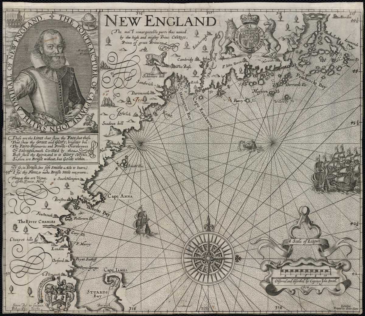
Upon his return to England, Smith published in his 1616 book the first map that accurately displays the coast of Maine and Massachusetts. In the book’s dialogue, he raved endlessly about the promise of New England and how the Amerindians could be easily subjugated to serve the settlers. It promoted Smith as a potential travel guide who could serve as an important resource for people wanting to migrate there. The Pilgrims nearly selected him in 1620 to be their advisor but instead selected Miles Standish. They did, however, use his map of New England to find their way to Plymouth.
The fowl deed of Thomas Hunt
When he had finished exploring New England, Smith returned home leaving his lieutenant Thomas Hunt behind. Hunt’s instructions were to continue fishing and trading until his ship’s hull was full. However, Hunt’s mission took on a dark and ominous turn when he decided to engage in the slave trading business to enhance his personal profit from the voyage. He seized at least twenty-seven people from around Cape Cod and Martha’s Vineyard, to sell into Spanish slavery.
Smith (1616) was convinced that Hunt’s actions were directed at him; by inflaming the local population, Smith said, he could “prevent that intent I had to make a plantation there“, keeping the country in “obscurity” so that Hunt and a few merchants could monopolize it. According to Smith, Hunt had taken his maps and notes of the area to defeat Smith’s settlement plans. He could not believe that Hunt was driven by greed since there was “little private gain” to be gotten; Hunt “sold those silly Salvages for Rials of eight.”
The captives were carried off to Malaga, Spain, where Hunt tried to sell them at £20 each. Some of the local monks discovered what was happening. They took the remaining Indians from Hunt in order “to instruct them in the Christian faith, thus disappointing this unworthy fellow of the hopes of gain he conceived to make by this new and devilish plot.” (Burrage, 1923: 144).
One of the Ameridians named Tisquantum (more commonly known as Squanto) lived with the monks for a year or two until he made his way to London under the care of John Slaney, a merchant, treasurer of the Newfoundland Company, and a shipbuilder. As will be described in another blog, Tisquantum would become a key player in the English exploration and settlement of America.
Illustration: John Smith’s 1616 map of New England
Bibliography:
Burrage, H. S. (1923) Gorges and the grant of the Province of Maine 1622, A tercentenary memorial. State of Maine.
Smith, J. (1865) [1616] A Description of New England or Observations and Discoveries in the North of America in the Year of our Lord, 1615. William Veazie, Boston (1865) Reprint. Originally published: H. Lownes, for R. Clerke, London.
