When Columbus first touched the Americas in 1492, there was a massive indigenous population in the western hemisphere of 40–100 million. Denevan (1992) suggested a New World total of 53.9 million, divided into 3.8 million in North America, 17.2 million in Mexico, 5.6 million in Central America, 3.0 million in the Caribbean, 15.7 million in the Andes, and 8.6 million in lowland South America. Europe’s population at the time was 70 to 88 million spread over less than half the area.
To feed this huge population of people, a vast and intricate agriculture had evolved over a millennium. “To observers in the sixteenth century, the most visible manifestation of the Native American landscape must have been the cultivated fields, which were concentrated around villages and houses. Most fields are ephemeral, their presence quickly erased when farmers migrate or die, but there are many eye-witness accounts of the great extent of the fields. On Hispaniola, chroniclers Las Casas and Oviedo reported there were individual fields with thousands of montones, manioc and sweet potato mounds 3–4 m in circumference, of which none have survived” (Denevan 1992).
New World agriculture “consisted of terraces, irrigation works, raised fields, sunken fields, drainage ditches, dams, reservoirs, diversion walls, and field borders that numbered in the millions and are distributed throughout the Americas. For example, about 500,000 ha of abandoned raised fields survive in the San Jorge Basin of northern Columbia and at least 600,000 ha of terracing, mostly of prehistoric origin, occur in the Peruvian Andes. There are 19,000 ha of visible raised fields in just the sustaining area of Tiwanaku at Lake Titicaca and there were about 12,000 ha of chinampas (raised fields) around the Aztec capital of Tenochtitlan” (Denevan 1992). In 1539, Hernando de Soto’s army passed through numerous fields of maize, beans, and squash in northern Florida, which became their main source of food.
Long before the Colonial Period, the Amerindians had developed agricultural technologies and cultural practices which allowed them to crop in a wide range of environments and ecological conditions. “Some of these cultivated landscapes consisted of intermingled or patchwork-like microsystems, fine-tuned to small-scale environmental variations, while others were dominated by zonal patterns keyed to the broad environmental zones created by elevation, aspect, and slope” (Whitmore and Turner 1992). “Complex canal systems on the north coast of Peru and in the Salt River Valley in Arizona irrigated more land in prehistory than is cultivated today” (Denevan 1992). The conquistadores marveled at these agricultural landscapes, even though their actions altered them forever.
In their agriculture, the Europeans had two great advantages over the indigenous people of the Americas – large domestic animals and iron. Iron gave them more durable, sharper tools, while their beasts of burden allowed them to cultivate large stretches of land with much greater ease using plows and harrows. They could also graze herds of sheep and cattle on agriculturally poor land to produce food, hide, and wool.
However, even without iron and oxen, the great civilizations of the Americas developed agricultural systems that clearly rivaled the Europeans. They terraced hills and mountains at a level unknown in Europe, they developed complex irrigation systems using canals, weirs, and dams that matched the most intricate found in the Old World (Denevan 2001). They rotated crops, left land fallow to regenerate, and fertilized with guano. The level of land management employed by the Maya in their Milpa system was unheard of in Europe and nothing in the Old World compared with the massive Chinampas of the Aztecs that covered thousands of hectares in the freshwater lakes of central Mexico, or the grid gardens of the Puebla.
As described by Knapp (2007): “In late pre-Columbian times, the northern and central Andes (and adjacent coastal lowlands) were the main locus of intensive agriculture and landscape impacts. The highest arable slopes were used for potato cultivation that employed long fallows and rotational systems. Below about 3,000 meters, maize cultivation had led to massive landscape transformation. Irrigation canals snaked through the landscape, enabling farmers to produce reliable harvests even in areas with uncertain rainfall (Knapp 1992). In the south-central Andes, from what is now central Perú to northern Chile, true agricultural terracing (bench terracing) was widespread (Donkin 1979). Raised fields were deployed in highland plains (altiplanos) from Colombia to Bolivia. Desert coastal valleys were irrigated for a variety of crops; and canals, water-table farming, raised fields, embanked fields, and sunken fields were deployed (Knapp 1978, 1982). Humid coastal and Amazon lowland areas were also sometimes cultivated by using raised fields.”
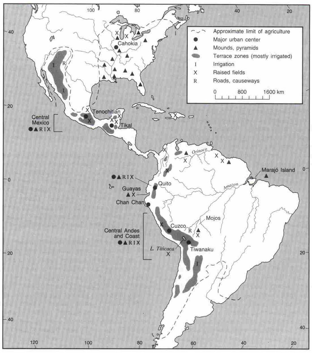
Map: Agricultural development in 1492. William Denevan (1992, The Pristine Myth: The Landscape of the Americas in 1492. Annals of the Association of American Geographers 82: 369-385)
Bibliography
Denevan WM (1992) The pristine myth: the landscape of the Americas in 1492. Ann Assoc Am Geogr 82(3):369–385
Denevan WM (2001) Cultivated landscapes of native Amazonia and the Andes. Oxford University Press, New York
Knapp G (1978) The sunken fields of Chilca: horticulture, microenvironment, and history in the Peruvian Coastal Desert. M.S. thesis, University of Wisconsin, Madison
Knapp G (1982) Prehistoric flood management on the Peruvian coast: reinterpreting the “sunken fields” of Chilca. Am Antiq 47:144–154
Knapp G (1992) Riego precolonial y tradicional en la Sierra Norte del Ecuador. Hombre y Ambiente, 22, Abya Yala, Quito
Knapp G (2007) The legacy of European colonialism. Chapter 17. In: Veblen TT, Young KR, Orme AR (eds) The physical geography of South America. Oxford University Press, New York
